26. Boulder Lake Loop
Summary
Length 7.5-mile loop
Difficulty Difficult
Season Summer to early autumn
Elevation range 4,030 feet – 5,490 feet
Human imprint Moderate (road, campground)
Information Mt. Hood National Forest (Barlow Ranger District)
Primary old growth features
Impressive eastside Douglas-fir; wide variety of old-growth types.
Description
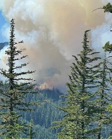
Upper Boulder Creek basin holds some of the finest, readily accessible old growth left on the east side of Mount Hood National Forest. Segments of three trails and a road can be linked together forming a 7.5-mile loop through the basin, showcasing an ever-changing assemblage of old forest types. The Boulder Fire (2023) ignited near the trailhead, but burned to the south towards Little Boulder Lake and had minimal effect on this hike.
Start uphill (west) on the Boulder Lake Trail (463) and immediately enter an old-growth stand dominated by noble fir and Douglas-fir 4 to 5 feet thick. Two trail junctions are reached just prior to arrival at pretty Boulder Lake less than a half mile from the trailhead. The first (463A) extends a half mile to Little Boulder Lake; the second (463B) loops around cliff-lined Boulder Lake, rejoining the Boulder Lake Trail by the northeast corner of the lake.
To continue the loop, head north past the lake over a minor ridge quickly coming to Kane Springs where hefty noble fir, Engelmann spruce, Pacific silver fir, and mountain hemlock cluster nearby. Switchback up the hill to Bonney Meadows Campground. Find your way through the campground out to Forest Road 4891 and take a right. Follow the road for a mile, coming to the Crane Prairie Trail (464) on your right.
Head downhill passing through a 300-year-old mountain hemlock and Pacific silver fir forest. The trail steepens along the spine of a narrow ridge a mile later where large Douglas-fir 4 to 5 feet thick crown the ridgeline. The trail soon flattens out, first crossing the stream on the right side of the ridge, then crossing the larger stream on the left side of the ridge. Once across the stream the trail enters a small marshy area populated by stout Engelmann spruce. The trail can be difficult to follow through this soggy spot, but cut logs and other indicators point the way through.
Turn right onto the Crane Creek Trail (478) a half mile past the stream crossing (5 ½ miles from the trailhead) and soon enter an old Engelmann spruce, Pacific silver fir, and noble fir forest. Look for a huge, solitary black cottonwood a half mile past the trail junction. Douglas-fir, western white pine, and western larch replace the spruce and true firs as the trail loses elevation. Several immense, fire-scorched Douglas-fir 6 to 7 feet in diameter squeeze the trail near a talus slope where groves of quaking aspen tremble in the breeze. Turn right back onto the Boulder Lake Trail (463) shortly thereafter, crossing a trail bridge back over Boulder Creek and heading uphill through more old forest for the final half mile.
30 years of change
The nearby Boulder Fire (2023) is evident, but had minimal impact to the trailside forest.
How to get there
Turn southeast onto FR 48 from State Highway 35 approximately 4 ½ miles northeast of the U.S. Highway 26/State Highway 35 junction (33 ½ miles south of the town of Hood River). Follow FR 48 for 14 miles and turn left onto FR 4880. Stay on FR 4880, bearing right where the road becomes gravel-surfaced after 2 ½ miles. Trailhead parking is on the left 4 miles later.

Noble fir in the mist

Boulder Lake

Boulder Fire (2023; US Forest Service image)
